Wellington to Auckland Road Trip

Flew to Wellington, stayed overnight in Wellington at the Cambridge Hotel near town. Visited Te Papa, Parliament (doing the Parliaments Highlights tour), Botanic Gardens (Taking the cable car up), Mount Victoria.  Weather was wet pretty much the entire time I was there, with some brief periods of the sun trying to break through.

Sunrise while flying to Wellington

Next day, decided to leave the wet weather behind, grabbed a hire car from the Wellington Thrifty Branch and headed north, via Wairarapa before staying the night in Palmerston North / Manuwatu

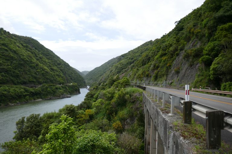
On the next morning, the Wet weather had caught me up, visited Manawatu Gorge then drove onwards to Whanganui before heading to Taumarunui for a snooze.

On the final leg, stopped by Ruakuri caves and then headed directly back to Auckland.

Wellington to Auckland Road Trip

Epiphyllum Oxypetalum

Pictures of Epiphyllum Oxypetalum Flowers. Opens only once a year at night.

23rd June 2020: This plant is no longer in my possession and has since been given to a relative down country.

Have been receiving the occasional inquiry about where to possibly acquire this plant (or clippings of) from site visitors both locally and overseas. If people know of any Garden centres (or otherwise) in New Zealand that may be able to supply this plant or otherwise assist, please do state in the comments below to help out fellow Netizens :o) Thanks!


Epiphyllum Oxypetalum

Goldie Bush Mokoroa Stream Bash

Easier stream bash along Mokoroa Stream (Goldie Bush). Pictures uploaded to Mokoroa Stream Track album.

Beware, the trail head of this reserve now has parking enforcement at the Horseman Road End. Avoid parking on the side with the “No Stopping” / “No Parking” signs. Upon our arrival, we saw a Parking warden going around issuing tickets.

Swing bridge along Goldie Bush Track
Goldie Bush Mokoroa Stream Bash

A walk through the forest before it’s deletion

When to explore Moirs Hill Walkway before the Pine Forest surrounding it gets deleted.  Including an explore around Pohuehue Falls.  Photos posted to NUI.NZ.

Moirs Hill Walkway

Walked to the Moirs Hill Road end, returned back the same way back to Beverley Price Loop Track and returned down the other way to complete the loop. Although several cars were parked there at the Pohuehue Car Park, I did not meet anyone on the trail itself… Most cars had just pulled off to have a rest.

Have to admit, struggled a little with 25°C heat which I found zapped my energy levels (hence, won’t be doing any hiking tomorrow as it has been forecast to be higher than that.).

The Pine Forest behind Pohuehue Scenic Reserve is going to be logged in preparation for expanding the Motorway North, hence the closure of Moirs Hills Walkway.

Total time spent on trail about 4 hours, includes a few bush bashes and side tracks (to explore).

A walk through the forest before it’s deletion

Short Saint Heliers Walking loop

21st December 2016 – Photos from a nice and easy short little walk around St Heliers with the Auckland Hiking Meetup Group Wednesday walks series. Hosted and led by Ruth Donde whom gave excellent commentary on the history of the area throughout.  Walk concluded with an excellent public performance by the Auckland City Brass

Short Saint Heliers Walking loop

Gills Scenic Reserve

A little, very short stroll around GIlls Scenic Reserve in Albany.  Pics uploaded to nui.nz

Started from the Lower end of the reserve at GIlls Road entrance and did a figure eight type of loop. There’s a possibility to enter the park at the Carol Lee Place end instead though car park when I walked past seemed to be full, however for some strange reason, I didn’t encounter anyone else in the reserve while I was there.

Apparently there’s some board walk section to this reserve, however, didn’t manage to find it.

Gills Scenic Reserve
Gills Scenic Reservie

Continue reading “Gills Scenic Reserve”

Gills Scenic Reserve

Spontaneous Pararaha Stream Day Walk

Did a spontaneous walk along Pararaha… Heck I wasn’t actually going to go all the way, (was going to stop at the log jam then head back) but continued on anyway.  Weather conditions were showery initially while I was walking down Buck Taylor track, but later cleared up once I embarked on the Pararaha Stream (after the Pararaha Campsite)

Grippy footwear really is a must for this.    You will most probably get your feet wet.  Dry bags for your more sensitive gear (e.g. Non-Waterproof electronics) is highly advisable.

Log Jam can be a little daunting, particularly the bit where you get through past the logs and then climb up a moderately sloped rock. Thankfully the rock is fairly grippy

While it is technically possible (after the log jam) to continue directly up the stream, there are 3 (or may be 4 Points) where it may be better to scramble up the side of a cliff for those who wish to avoid a full immersion swim. The cliff routes are failry well worn in, it’s just a matter of finding them… If you find that a section of stream is deeper than chest height, then there’s most probably an alternative cliff trail somewhere.

Regarding Still Gully, (According to the map posted to Auckland Hiking Group meetup, it seems they are planning to go up this). In short, It’s easy to miss, which may not be a bad thing because it’s difficult to go up it.  There’s a small stream and lots of thick bush and according to the Topo Map, it gets quite steep.  Tried for about a 100m then gave up.  There doesn’t appear to be much to see there (except dense vegetation).  I believe you are better to continue up Pararaha stream till you get to intersection of Odins TImber Trail and then turn left on to it to Odens TImber Trail and head back to the car park from there.

Will shortly upload photos to nui.nz

Spontaneous Pararaha Stream Day Walk

Hiking markers

We did have an incident in the Hunua’s last weekend where a 2 hikers from our group got separated and supposedly went down a possum trapping track.  Probably worth mentioning that in terms of the Auckland region at least.  Most trails are marked with…

OLYMPUS DIGITAL CAMERA

  1. An Orange plastic Triangle marker with the most pointy tip marking the direction of travel.
  2. Or an Pole (Orange or faded orange)

Please be aware, the Pink Triangles and ribbons are not the ones to follow (unless you are a trapper)

If one finds them off the track, in the bush, with no clear path direction and no orange markets, it would be wise advised to retrace your steps until you find Orange Makers.


Hiking markers